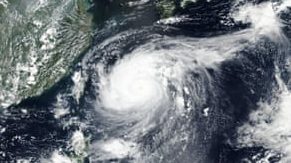
Typhoon Maysak will come off its peak and is forecast to make landfall in South Korea on Wednesday, passing to the east of the island of Jeju to come ashore between Busan and Goheung as a strong Category 1 or Category 2 storm.
The second typhoon in one week is making its way northward in the East China Sea, packing maximum sustained winds of 140 mph. The storm peaked early Tuesday with 145-mph winds, becoming the strongest typhoon of the year so far.
The storm’s track and intensity forecast is concerning, given that it would place Busan in the right front quadrant of the storm, which typically contains the strongest winds and worst storm-surge flood threat. With a population of 3.4 million, Busan is South Korea’s second-largest city and the world’s sixth-largest container port. This may impact cargo importing into or exporting from Korea, as well as cargo that transships from China to the U.S. via Busan.
Source: Washington Post


